Research

Selected work

One or two papers from each line of work, and what each established. The full record is on the publications page.

01  Dynamics

Spatial variations in tropical cyclone rainfall over the western North Pacific according to ENSO phase

Kim, D, D-S R Park*, and C Matyas
Journal of Climate 36:1697-1710 (2023)

Rainfall strength, area, and volume over the western North Pacific shift east and west with the phase of ENSO. The core intensifies where the wind does — westward in La Niña, eastward in El Niño — while the total area and volume follow the environment instead, rising through La Niña and falling through El Niño. Two different controls, separated.
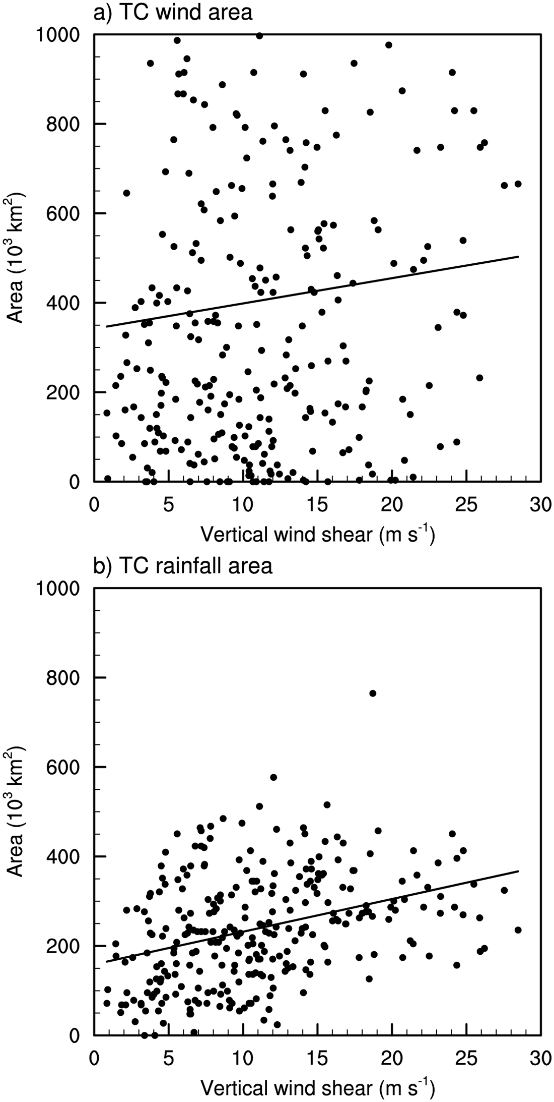
Wind area (a) is indifferent to vertical wind shear; rainfall area (b) grows with it. Figure 6 from the paper, CC BY 4.0.

Influence of vertical wind shear on wind- and rainfall areas of tropical cyclones making landfall over South Korea

Kim, D, C-H Ho, D-S R Park*, and J Kim
Plos One 14:e0209885 (2019)

For typhoons making landfall on Korea, vertical wind shear widens the rainfall area but leaves the wind area largely untouched. The asymmetry comes from shear-induced convection — rising downshear-left, sinking upshear-right — which is why the ground that gets soaked and the ground that gets blown are not the same ground.

02  Predictability

Effects of the assimilation of relative humidity reproduced from T-PARCII and Himawari-8 satellite imagery using dynamical initialization and ocean-coupled model: A case study of Typhoon Lan (2017)

Lee, J-D, D-S R Park*, K Ito, and C-C Wu
Journal of Geophysical Research 126:e2020JD034516 (2021)

A single storm, Typhoon Lan (2017), taken apart to find where the forecast lost it. Relative humidity reconstructed from T-PARCII dropsondes and Himawari-8 imagery was assimilated into a dynamically initialised, ocean-coupled model; intensity and convective structure both improved. The ocean coupling cooled the rear-right quadrant enough to suppress convection there — a reminder that a forecast fails through a mechanism, not through bad luck.

03  Climate

Western North Pacific tropical cyclone activity modulated by phytoplankton feedback under global warming

Kim, H-K, J-Y Park, D-S R Park*, J-S Kug, S-W Yeh, and J-H Son
Nature Climate Change 14:504-510 (2024)

Ocean biology turns out to sit in the causal chain. Earth system runs with the biogeochemical feedback switched on and off show that chlorophyll changes produce a La Niña-like warming pattern, strengthening the Walker and local Hadley circulations and raising the genesis potential index over the southeastern western North Pacific by 10%. A higher-resolution experiment puts the resulting increase in landfall frequency over East Asia at 27%.

Landfall intensity by latitude band under observation, control, and 2 K warming — the cool-SST barrier that weakens El Niño typhoons no longer holds. Figure 3 from the paper, CC BY 4.0.

Sea surface temperature warming to inhibit mitigation of tropical cyclone destructiveness over East Asia in El Niño

Park, D-S R*, E Seo, M Lee, D-H Cha, D Kim, C-H Ho, M-I Lee, H-S Kim, and S-K Min
npj Climate and Atmospheric Science 7:24 (2024)

El Niño normally protects East Asia: cool sea surface temperatures in the basin act as a barrier that weakens typhoons before they arrive. Pseudo-global-warming simulations show that 2 K of basin-wide warming breaks that barrier, so El Niño years would deliver more destructive landfalls rather than fewer. That much warming arrives by mid-century on a high-emission path.

04  Risk

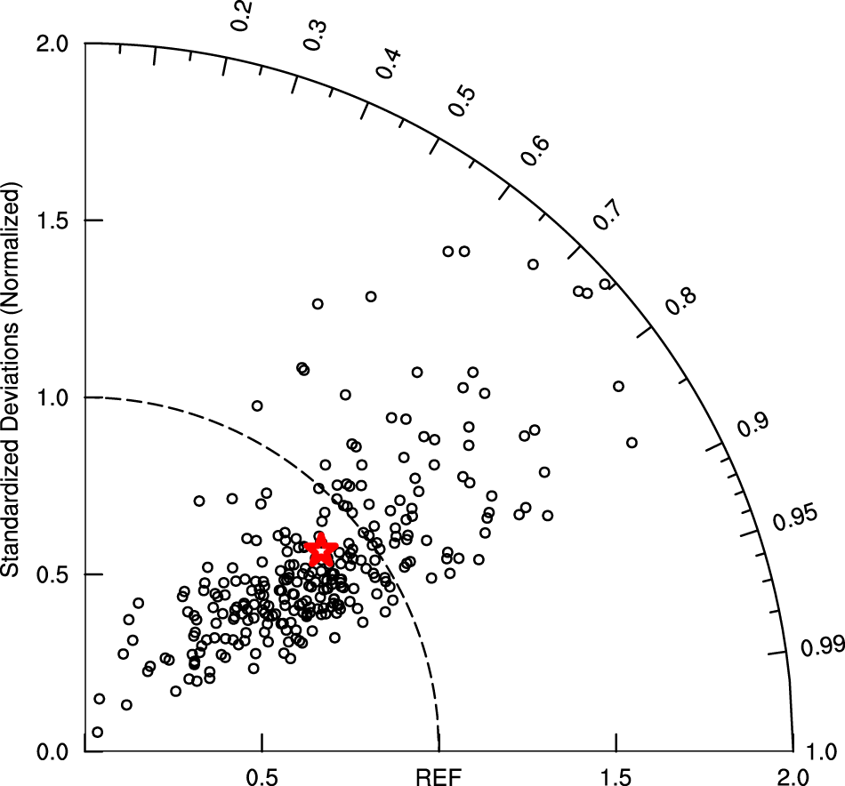
Pattern correlation and normalised standard deviation of accumulated landfall rainfall against TRMM observations. Figure 3 from the paper, CC BY 4.0.

The parametric hurricane rainfall model with moisture and its application to climate change projections

Kim, D, D-S R Park*, C C Nam, and M Bell
npj Climate and Atmospheric Science 5:86 (2022)

The parametric hurricane rainfall model had no way to represent the extra water vapour a warmer troposphere holds, which left it unusable for climate projection. Adding moisture — and retraining on western North Pacific storms rather than US ones — produced a model that beats existing statistical and operational forecasts at landfall, and is cheap enough to run across the thousands of storms a catastrophe model needs.

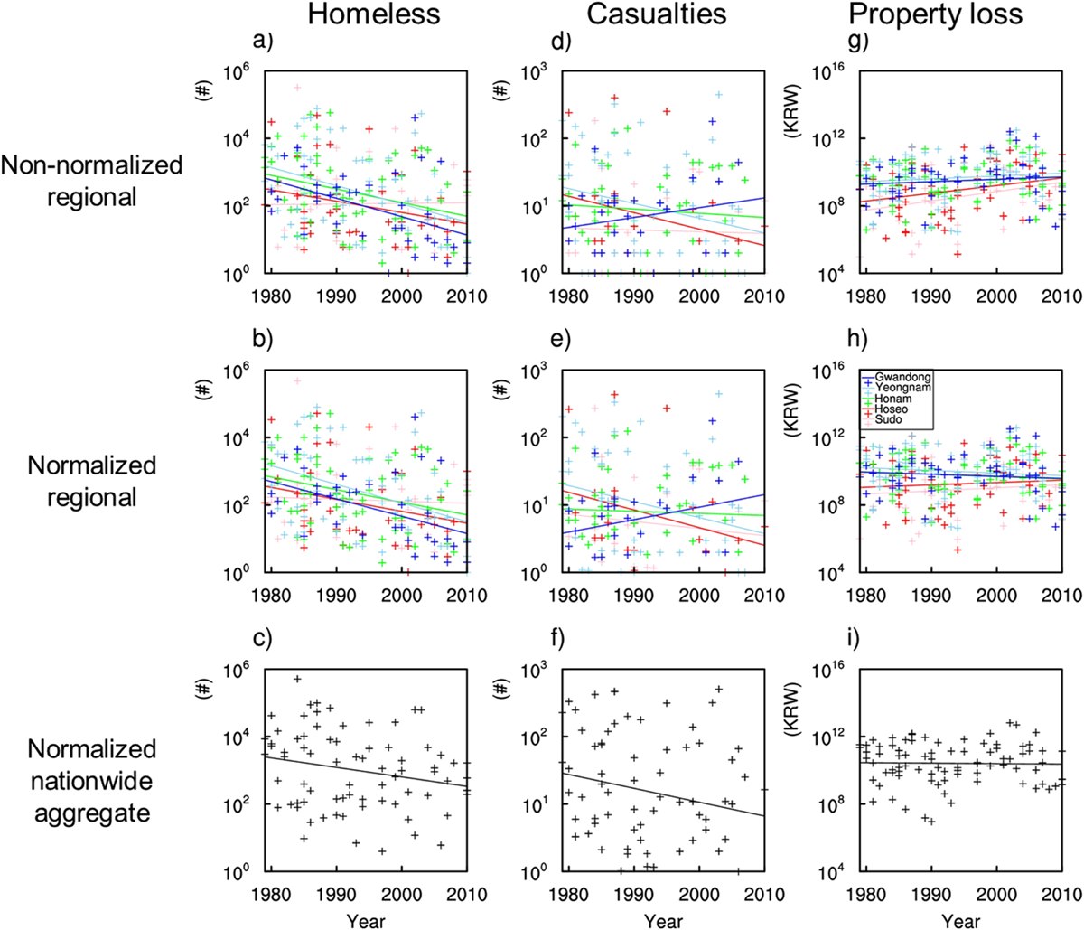
Homelessness, casualties, and property loss per landfall — raw, normalised by region, and nationwide. Figure 3 from the paper, CC BY 3.0.

Evidence of reduced vulnerability to tropical cyclones in the Republic of Korea

Park, D-S R, C-H Ho, C C Nam, and H-S Kim
Environmental Research Letters 10:054003 (2015)

Korea spends heavily on typhoon prevention, and nobody had checked whether it works. Normalising homelessness, casualties, and property loss to 2005 conditions and regressing them on hazard and income across provinces, 1979–2010, gives a consistently negative income coefficient: vulnerability has fallen. The same analysis shows rainfall, not wind, to be the dominant damage factor in Korea.

Beyond storms

The same approach — find the mechanism in the observations, then test it in model experiments or against a larger sample — carries over to other questions we work on: wintertime and summertime temperature extremes over South Korea, synoptic controls on PM2.5 air quality in Seoul and other cities, Arctic sea-ice decline and polar feedbacks, and spring drought and precipitation variability across East Asia.

See the full publication record →